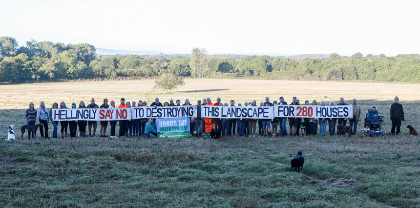
HELLINGLY residents gathered in the countryside this morning to protest against plans to build up to 280 homes on land at Shawpits Farm.
Villagers met on a public footpath running through the proposed development site, north of Mill Lane, where they unfurled a 20-foot banner declaring: “Hellingly say no to destroying this landscape for 280 houses.”
The demonstration was organised in response to outline planning application WD/2026/1679/MAO, which seeks permission for a development of up to 280 homes on land described in the application documents as Chestnut Cross.
More than 250 representations from local residents have been submitted to Wealden District Council’s planning portal in connection with the application.
Residents behind the campaign say they are not opposed to new housing in principle, but believe the site is unsuitable for development on this scale.
Among their main concerns are existing flooding and drainage problems, sewage capacity, additional traffic on surrounding roads and the potential impact on wildlife, agricultural land and the rural character of Hellingly.
However, documents submitted on behalf of applicant Hallam Land argue that the development has been designed to address a number of these issues.
The applicant describes the scheme as a “logical extension” to the northern edge of Hailsham and says the development would include extensive green space, pedestrian and cycle connections and a 2.45-hectare nature park. The plans propose retaining the overwhelming majority of existing trees and hedgerows, alongside new tree and hedgerow planting.
Flooding concerns
Flooding was one of the main issues raised by residents at this morning’s protest.
Dr Colin Tourle MBE, 83, has lived at Brook Cottage for 56 years and worked as a GP in the community for 50 years.
He said: “My wife Jane and I already experience regular flooding, and I am deeply concerned about the consequences of putting another development of this size into an area where flooding and drainage are already serious problems.
“We need new homes, but they have to be built in the right places. I simply cannot see how adding up to 280 houses here can be sensible when existing residents are already living with flood risk.”
The Flood Risk Assessment submitted with the application acknowledges that while the majority of the site is in Flood Zone 1, areas along its western boundary are within Flood Zones 2 and 3. It proposes keeping development out of those higher-risk areas.
The assessment also considers the effect of surface water generated by replacing currently undeveloped land with roads, homes and other hard surfaces. Its proposed drainage strategy would restrict surface water leaving the development to the equivalent existing “greenfield” rate, with additional water stored in attenuation features before being discharged towards the River Cuckmere.
The wider design includes swales – shallow landscaped channels intended to collect and slow rainwater – which would feed into a series of attenuation basins between the housing and the proposed nature area on the western side of the site.
The applicant’s Flood Risk Assessment concludes that, subject to the proposed management of surface water, the development would not increase flood risk elsewhere. It also identifies the risk of sewer flooding at the site itself as low because there are no sewers within the site and it sits above the public sewer network.
‘Permanently change the character’
Maire Stone, whose land at Kenwood Brook borders Mill Lane beside the River Cuckmere, said she had witnessed how quickly the surrounding land can become saturated during her 22 years there.
She said: “With up to 280 houses proposed further up the land, we are very concerned about the additional run-off and the effect this could have, not only on our land but on other residents in the area who already experience flooding.
“But it is about much more than flooding. This is a beautiful rural part of Hellingly with the River Cuckmere, fields, wildlife and an established landscape that has been here for generations. A development of this scale would permanently change the character of the area.”
The application acknowledges that the site lies partly within an Area of Locally Valued Landscape identified by the Hellingly Neighbourhood Plan, although it is not within a nationally designated landscape.
The applicant says the scheme has been designed to create a transition between the new homes and surrounding countryside, with green corridors running through the development and new habitats being created.
A separate Biodiversity Net Gain Assessment says the development is intended to achieve at least a 20 per cent biodiversity net gain, using a combination of habitats created and managed on the site and, where necessary, biodiversity units secured elsewhere.
Traffic concerns
Traffic is another major concern for campaigners, particularly along Mill Lane and Station Road.
Doug Lewin, Vice-Chair of Hellingly Parish Council, said: “Hellingly has already absorbed a great deal of development, and residents are increasingly concerned about the cumulative impact on the village.
“This application raises serious questions about traffic, flooding and drainage, infrastructure, ecology, heritage and the suitability of Mill Lane for development on this scale.
“The issue is not whether homes are needed. It is whether this is the right site for up to 280 of them, and whether the infrastructure and rural environment of Hellingly can sustain the consequences.”
Under the plans, the main vehicle access would be created at the south-eastern corner of the development, with part of Mill Lane realigned. The section immediately west of Grove Hill would be widened, with a shared footway and cycleway and a new pedestrian crossing proposed.
The development would also include several pedestrian and cycle access points connecting with existing public rights of way and the Cuckoo Trail.
Serena Schellenberg, who is helping organise the residents’ campaign, said: “We know homes are needed, but that doesn’t mean every beautiful piece of countryside is the right place to build them.
“Shawpits is part of what makes Hellingly Hellingly. It is open countryside crossed by a much-loved public footpath, surrounded by wildlife, historic buildings and the River Cuckmere.
“We are asking Wealden District Council to look at the whole picture: the flooding we already experience, our overloaded infrastructure, the traffic on rural roads, the ecology and heritage of this landscape, and the cumulative impact of development on our village.”
The outline application remains under consideration by Wealden District Council.